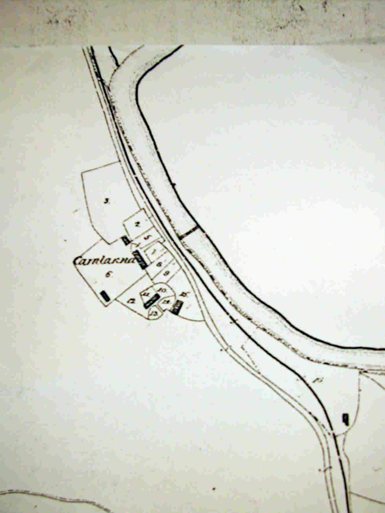
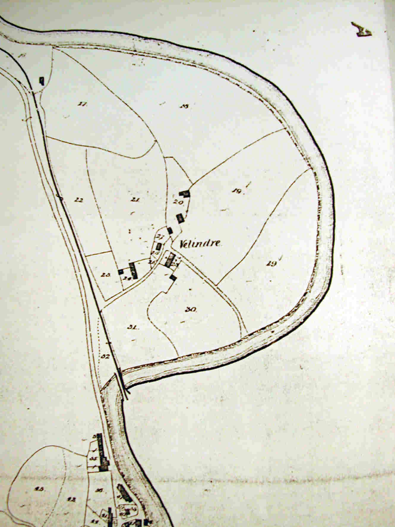
The map indicates the boundaries of individual fields and the existence of buildings, such as barns and stables, as well as dwellings. Each of the properties is identified by a number, which is shown on the map, and buildings are shaded red for dwellings, or grey for barns, outbuildings etc.. Rivers and ponds are shaded in blue on the original map. The apportionments should identify both the owner and occupier of each numbered property, with a description or name for each property and the area covered. [The area is given in acres, roods and poles - there are 4 roods in one acre and 40 poles in one rood]. The apportionments should also indicate whether a field is arable, pasture or woodland. A list of cottages and tenements exempt from tithe by agreement is often included in the apportionments list, with details of the owners and occupiers.
Although the tithe maps are very detailed, the information is not necessarily accurate. The Act did not insist that a new survey be carried out, and in some cases old surveys of doubtful accuracy were used to save expense. However, many of the maps produced for parishe of Aberavon appears to be substantially accurate. Comparing the tithe map with later Ordnance Survey maps shows that many of the field boundaries and wooded areas remain unchanged into the 20th century.
1840 Tithe. Aberavon.
-----------------------------------
The complete map measures roughly 1600 mm. square in size.
So we have split the map up into four sections, starting in the north
of the parish,
and ending at the foreshore. Each named as follows-.
1. Carnlarna.
2. Velindre.
3. Upper Town. [ All north side of High Street, from Aberavon Bridge to
Baglan boundery.]
4 . Lower Town.
Back to the Top
 Click the image for a scroll map then click the square arrows icon bottom right corner Reproduced from the 1876 Ordnance Survey Map. Crown Copyright. Also thanks to the West Glamorgan Archive Service, who produced it in colour. |
OCCUPIERERS 2.Rees Hopkins. Arable field, no dwelling ./ 3.Pollard Jones. Pasture field./ 5.David Hopkins. Cottage & garden./ 6.Daniel Jenkins. Cottage & garden./ 7.Edward Jones. Cottage & garden./ 8.William Rees. Cottage & garden./ 9.Thomas Griffiths. Cottage & garden./ 10.Hopkin Thomas Cottage & garden./ 11.William Bossingcombe Cottage & garden./ 12.Thomas Jones garden./ 13,Thomas Jones Cottage & garden./ 14.Thomas Edwards Cottage & garden./ 15.Anni Thomas Cottage & garden./ |
LANDOWNEER Anne Bamford Aberavon Burgeses Same Same Same Same Same Same Same Same Same Same Same Same Same |
Back to the Top
At Velindre 1840 Tithe.
 Click the image for a scroll map then click the square arrows icon bottom right corner Reproduced from the 1876 Ordnance Survey Map. Crown Copyright. Also thanks to the West Glamorgan Archive Service, who produced it in colour. |
|
Occupiers. 16.Copper.Miners
18.Jehosaphat Powell Field Cae Uchaf. 19. Same. Field Cae Cenol. 20. Same. Cottages & gardens. 21.David Longdon. Field a meadow. 22.Same. Field Caer Mynydd. 23.Same. Field pasure land. 24.Same. Homestead. 25.Rees David. Garden. 27.Same . Garden. 28.Same. Homestead. 29.Jehosaphat Powell Field Cae Uchaf. 30.Same. Field Cae Clover. 31.Same. Field rye grass. 32.Copper.Miners
33.Burgesses. Mountain. Aberavon |
Landowners. in England Governor and Company of And John David. Houses & gardens. John David. John David. Lord Jersey. Same. Same. John David. Same. Same. Same. C.R.M.Talbot. Same. Same. Lord Jersey. Same. Same. in England Governor and Company of. Sand under railroad. C.R.M.Talbot. Burgesses. |